How To Predict Earthquakes
TUESDAY FEBRUARY 01, 2011
Below is a chart that may help you prepare for the possibility of the major earthquakes through 2011. It is a global estimation and so you should add and subtract 1-day for error, to account for UTC and local time variations. These are not predictions or certainties, they are potentials for increased tectonic activity and clustering. They equally apply to other extreme weather events, like cyclones and hurricanes (when in the season), storms producing flooding, and higher tides.
Update added 25 March:
A misconception should be cleared. The magnitudes here do not relate to any particular country. Neither are they numerically predictive; they only indicate potentials. For example, over thirty 7+ are indicated, but that does not mean that many 7+magnitude earthquakes, at least one per month. What it only means is that on a date that has strong lunar significance, like 20 March, a 7+ is very likely somewhere.
It is akin to a dangerous corner, which by its design might have the potential to cause 10 fatalities per year. It is most unlikely that that number will actually occur, but the figure is an estimate for each corner based on the geographical hazard. Similarly it is unlikely that a 7+ will occur every single month as shown here.
This has been the subject of widespread misquoting by the NZ media. At no time have I claimed that a 7+ event would occur in Christchurch on 20 March 2011. The estimation of magnitude is not something I nor most qualified seismologists are prepared to do. The moon method offers timing, not amounts. With earthquakes, the depth is the wild card and immeasurable beforehand.
On 20 March 5+ events were catalogued - at the Kermadecs, in the BoP, in Aranui, Christchurch, and in Twizel. At lunchtime at -44S latitude and 169E longitude four 4+ events were recorded. It was a very active earthquake day with over 45x shakes across NZ. Just a week before, when the moon was already in nearly in perigee and sitting directly above Japan, the two 7+ earthquakes struck. That was one for the history books. Perhaps not so for us but as I said many months ago, it could have been, given the position of the moon. Thank goodness there was no loss of life.
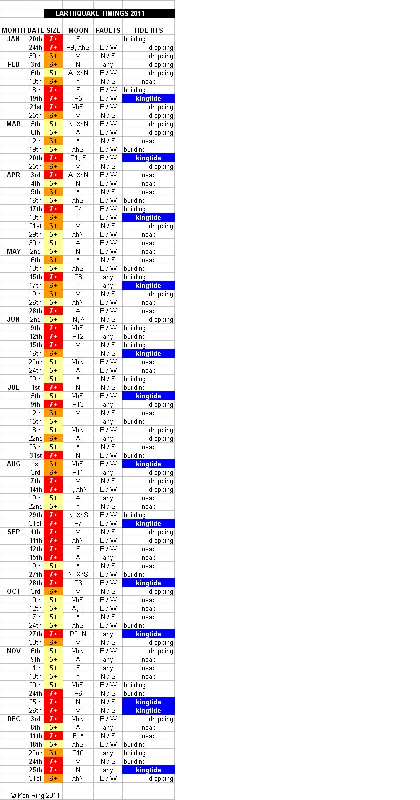
This is a general table for the globe, but we are mainly talking about the Pacific 'Ring of Fire' which sees 90% of all earthquakes, with about 80% of the largest, and where 15-18 significantly high events can occur in a year. The Ring of Fire encircles the Pacific, and includes all of NZ and parts of Australia, Japan, north across the Aleutian Islands of Alaska, and south along the coast of North and South America, including Canada, California (and the San Andreas Fault), Mexico, Chile and Antarctica. Most earthquakes occur at fault zones, running either east/west or north/south. It is called the Ring of Fire because volcanoes in each of these countries are still active.
In the Southern Hemisphere, the highest ocean tides of the day occur usually in the morning in the summer time and in afternoon or evening in wintertime. If the tide height doesn’t get to a certain height in the morning tide then it certainly won’t on the afternoon tide. It is the same with the magnitude of earthquake and aftershock events. And so if there are earthquakes or storms or floods that occur in the summer time, it's in the morning that we have to be alert to, because it's during this period of peak tide that those events can do the most damage. And so if there are such events that occur in the winter, it's in the early evening that we have to watch.
That means in the opposite hemisphere the reverse is the case, for example in Southern California, so that the highest tides of the day occur in early morning in their winter time and in early evening or late afternoon in their summer time. And so if there are storms that occur in the winter, it's in the early morning that they have to be alert to this, because for the northern hemisphere it's during this period of peak tide that those storms can do the most damage.
I have mentioned land and sea and air together, as if they are one tide. Well, they are. Earthquakes occur when there are maximum astronomical tidal stresses on the earth. Twice a month the centers of the earth, sun and moon at the time of new or full moon form a line that creates more gravitational pull on Earth and everything on the earth, which includes the molten outer core within the earth and upper mantle, the land which "rides" over the molten part, called the crust, and the sea which sloshes where it can. Above the sea the air also has kingtides around new and full moon times, as evidenced by the greater height weather balloons have been shown to reach on new and full moon days. This implies that we should be able to use sea-tides' to predict earthquakes.
The second most important stress-tidal effect is the closest approach of the moon to the Earth once every 27.5 days at perigee. The effect is dramatically enhanced when full or new moons and perigee occur on the same day, however this occurs only from 2-5 times a year. Such coincidences, which some astrologers call super moons, usually create an 8-day window of high seismic potential as well as other extreme weather effects. In 2011 these days will occur on 19 March, 17April and 26 October. On averages, it has been found that full moons are usually the most potent time for earthquakes.
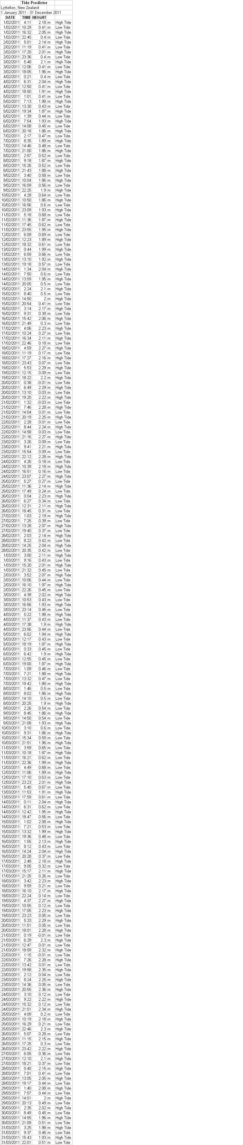
Tide-raising forces anywhere are directly proportional to the mass and to the cube of the distance between those masses. Because of the sun's increased distance, the moon has about 2.5 times the tidal effect that the sun has on the earth, despite the much greater mass of the sun. Based upon the rapid daily rise to peak tides, the seismic window may open up to three days before new or full moon. Such was the case prior to the strongest known European quake which hit Lisbon, Portugal on Nov. 1, 1755 just three days before the highest tidal forces of the year. It was also the case on the 4 September 7.1 earthquake in Christchurch.
In the above table I have added the tidal movements building and dropping between kingtides and neaps, so during any eight-day window you can count day-to-day decline in the maximum range in tides. In another article on this website http://www.predictweather.co.nz/ArticleShow.aspx?ID=306&type=home I described the effect of the maximum nodal point of the moon, which attains its most northerly orbit every 19 years, and was the case for the 4 September event, when the moon at north node occurred at 1-hr previous to the 7.1-mag earthquake. The node lines up moon and earth with no parallax, creating a potentially stronger triggering of the tectonic plates. Professor Jim Berkland found that 6+mag quakes on the San Andreas Fault system of Southern California tended to occur near dawn or dusk at lunar nodes, exactly as for the Christchurch event.
As for times of day the earthquakes may strike, these may be at or near the high and low tide times of the sea or at those times that are midway between high and low tides. This can equate to about every 3 hours, meaning there are 8 potential danger times in a 24-hr period, on an active day. It does not mean that every 3 hours one should expect a major earthquake, but dictates the most common time for earthquakes to be triggered, and implies that if a shake or aftershock occurs, one may be able to wait until it has passed and then prepare for the next lot either 2-3 hours later or on other multiples of 3 hours. The barometer also indicates when an earthquake is about to occur; more on this later.
It does not matter if a location is inland as there will still be a virtual tide. One can calculate the geomagnetic tide as if the location was at a coast. Dr Frank A. Brown of Northwestern University demonstrated this by relocating oysters 1000 miles inland from Long Island NY, and noticing that after two weeks they all (independently) opened and closed to a new tidal rhythm, suited to their new GPS location, even though each was in a dark pressurised tank. Migrating birds also appear to have this facility.
Can we predict exactly where a major event will strike? Not well at this stage, but there is no reason why this may not be developed as a valid science. It may require an initial dropping of the prejudice against the moon that is currently held by mainstream science, and a willingness for geologists, astronomers, meteorologists, seismologists and astrometeorologists to work together for a common goal. I do look forward to that day. Astrologers can already calculate the position and direction of of the moon's energies for particluar countries at fairly precise times.
As this is a work in progress this article will be added to as the earthquake year now unfolds. This is not an attempt to frighten people who already suffer trauma from very recent earthquake activity; rather it is the opposite, a desire to put some perspective to something that has affected mankind for millions of years. Scientists presently claim that earthquakes are unpredictable. I disagree, and perhaps this project may at last provide the smoking gun that finally establishes a moon-earthquake link. By following this, people might realise for themselves that these terrible tectonic occurrences that so destroy homes, livelihoods and the human spirit can indeed by somewhat calculated in advance.
As this is an experiment, if I am incorrect in my dates then I am willing to bow my head in defeat and go back to the drawing boaed. On the other hand if the exercise is at least fairly successful, we may be on the road to a new chapter in developing earthquake preparedness.
The abbreviations for the moon phases and positions are N=new moon, F=full moon, P=perigee,(e.g. P#4=fourth closest for the year), A=apogee, XhS=moon crossing equator heading south, also called lunar equinox, XhN=moon crossing equator heading north, ^=northern declination, or the moon's northernmost point in a 27.3 day cycle, V=southern declination, or the moon's southernmost point in this cycle. Northern declination was also once known as north stitial colure, southern declination was known as south stitial colure.
Feb/March tide chart for Lyttelton, Christchurch, NZ
Earthquake updates as they occur: Note that the bigger ones seem to come on or around the high tide
1 Feb, 7.13am (mid tide), 2.8mag, 212kg
1 Feb, 13.26pm (mid tide), 3mag, 483kg
2 Feb, 17.36pm (high tide), 2.9mag, 323kng
3 Feb; 12.14pm (low tide), 2.7mag, 186kg
3 Feb, 14.39pm (mid tide), 2.7mag, 178kg
4 Feb, 7.33am (high tide), 4.5mag, 73 tons
4 Feb, 7.38am (high tide), 3.4mag, 2 tons
4 Feb, 9.33am (mid tide), 2.9mag, 375kg.
4 Feb, 17.56pm (high tide), 4.6mag, 103 tons
4 Feb, 18.17pm (high tide), 3.7mag, 6 tons
5 Feb, 12.12am (mid tide), 3.3mag, 1 ton
5 Feb, 11.08am (mid tide), 3.4mag, 2 tons
5 Feb, 12.52pm (low tide), 3.2mag, 985kg
Ken Ring, January 2011.