Christchurch earthquakes: a review
FRIDAY JANUARY 27, 2012
(Pic: NZ govt, see below for full URL)
Review of Christchurch earthquakes
The Spin
If you listened to Mayor Bob Parker you would think the earthquakes have been a mild annoyance and that the city is joyfully undergoing a refit. Bob uses words like :"exciting place to live", "another exciting announcement",
http://www.ccc.govt.nz/thecouncil/mayor/index.aspx
If you listened to the PM John Key you would think the government was 100% committed to a rebuild starting now. "2012 is about starting to rebuild a vibrant, strong city. The Government is totally committed to the reconstruction of Canterbury. That’s why we put aside $5.5 billion in last year’s Budget and created a whole new government department to lead the recovery effort."
http://www.scoop.co.nz/stories/PA1201/S00076/pm-speech-state-of-the-nation.htm
Not starting to, Mayor Parker says "We're in the middle of a rebuild"
(TV1 CloseUp, 26 January 2012). I guess soon we'll be reading that we'll be finishing the rebuild anytime soon.
However, down on the ground, where real people actually live, there appears to be a different story.
"Difficulties in rebuilding Christchurch are an example of failed urban governance and planning, a new survey shows"
http://www.stuff.co.nz/national/christchurch-earthquake/6299221/City-rebuild-queried-house-prices-too-high
"Fletchers are reluctant to start anything until at least July 2012.."
http://www.stuff.co.nz/the-press/news/christchurch-earthquake-2011/5777195/Earthquake-stalls-rebuild-start
"The actual physical rebuild of Christchurch won't be complex but will remain frustratingly on hold until the aftershocks tormenting the city come to an end, says Fletcher Building CEO Jonathan Ling."
http://www.nzherald.co.nz/rebuilding-christchurch-business/news/article.cfm?c_id=1503045&objectid=10734757
and this splendid article by Lara Strongman
‘resilience’ is a phrase used extensively by the media and government to try to contain the traumatised city’s afterlife..”
http://www.australiandesignreview.com/opinion/16811-resilience-toughness-and-damage
Assuming Fletchers believe what the geologists say "shakes triggered by the September 2010 quake could continue for 30 years says head geologist Dr Kelvin Berryman"
http://www.stuff.co.nz/the-press/news/christchurch-earthquake-2011/6232973/Aftershock-data-revised-to-assess-risk
so it is hard to see how the giant reconstruction building company will have any willingness to move the first sod of earth until 2042. Then, even if they did, who will insure it?: "insurance companies won't guarantee they will continue covering their properties.."
http://www.starcanterbury.co.nz/news/home-insurance-worries/1060852/
It is a pity there is such a disparity. Perhaps the reason morale is low is because words are not real. Spin is fine for the economy but it has a shelf-life. The people eventually will sour when they see nothing happening. Has Bob got a secret deal with an insurer? Have GNS knwledge about earthquakes stopping for good? Again, Dr Berryman ""But in 30 years' time, there are not going to be damaging earthquakes (we hope)".
http://www.stuff.co.nz/the-press/news/christchurch-earthquake-2011/6232973/Aftershock-data-revised-to-assess-risk
But there has never been a time earthquakes have stopped in Christchurch, so presumably that will this be the first time ever. It's like saying in 30 years time all the rain will have rained itself out. In 30 years time only half the population will still be on this earth and it is unlikely anyone will remember the head geologist's words, let alone hold him accountable.
____________________________________________________
The facts
Sometimes we forget about facts. We get so wound up in media stories, designed to sell newspapers, we forget to check things for ourselves. Media sell surprise and anguish. They do not concern themselves with what is true or not true. The truth even annoys them if it stands in the way of a story. Some of the below results may come as a surprise to the reader.
As with all the statements made in this article, links have been provided to quotes and claims, so they can be checked for authenticity.
Earthquakes diminishing in Christchurch?
Yes.
The table below is the monthly rates of numbers of earthquake events, just for Christchurch, recorded from September 1st, 2010 to end of 2011.
These figures came from Geonet, the official (and very easy to access) website of our own government scientists.
Anyone can verify these figures.
http://magma.geonet.org.nz/resources/quakesearch/
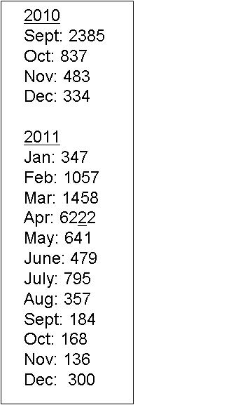
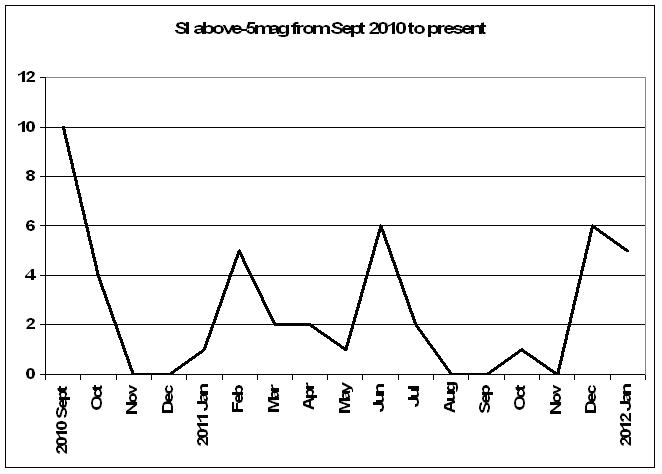
Whichever way the numbers are arranged, the fact is of lessening earthquake occurrence in the region. To a Christchurch resident, if that does not feel like being the case, I can certainly understand that feeling, but figures don't lie. Last month, December 2011, for Christchurch, by 22 December had seen only 78 events, the smallest number of monthly earthquakes since September 2010. But the next day the ground broke loose. There was a 6mag, three 5+mags, and eight 4+mags. But bad as it was, what happened on 23 December was an anomaly, not a brand new trend. It occurred because of extra sunspot activity+ solstice + lunar perigee. The 23rd -24th brought an amazing 90 earthquake events to Christchurch over 2 days. But it was not the start of a new pattern, because it has not continued.
Overall, the pattern has not changed much since my own unofficial last survey on 12 July which showed that the highest percentage of numbers between Sept 2010 and July 2011 (about 89%) had occurred by 30 April, and with figures that I was invited to share with Mark Sainsbury on TV1's CloseUp on 12 July 2011. The new figures are:
Number of earthquakes in Christchurch from 1 Sept 2011 to end December = 9975
Number between 1 Sept to 30 April = 7567
Overall percentage of recorded seismic events in Christchurch from 1 Sept until 30 April = 76%
Looking only at larger events, the numbers recorded of above-4 mag 1 September to present = 365
Overall percentage of above 4s from 1 Sept 2010 to 30 April: = 259 = 71%
This trend is less than was the total percentage up to 30 April, which was about 80-90%, but the events of December 23rd were irregular and have skewed percentages downwards by about 10-15 points, but not nearly enough to significantly alter the diminishing trend.
In February 2011 there was an increase in earthquake numbers. That was because of the return of close perigees (moon closer to earth creating more gravitational pull on land). Perigees have accompanied every next largest earthquake, and closer perigees (because they do vary throughout the year in distance) accompany every larger event.
A look back on the earthquake history since September 2010 will confirm that. Closer perigees were, in 2010, in the first week of September 2010, 7 October and the last week of December, and in 2011, on 19 February, 20 March, 12 June, last week in November and 22 December. These all brought the next largest earthquake events. It will be noted that March always coincides with equinox, which adds the influence of the Sun, and December, both 2010 and 2011, always coincides with solstice.
We can also note that in March 2011 the moon was the closest to earth for 17-19 years, depending on how this is calculated. On 12 March in Christchurch there were no less than 104 recorded events, the moon was being already in its closest position, and the day being the day of the occurrence of the Japan tsunami, the biggest ever recorded by that country. On 20 March, the day scientists said would be no earthquakes in Christchurch, having declared as such at a special Sceptics Lunch, there were no fewer than 26 recorded events in Christchurch alone, including three above 4s around lunchtime and a 7-intensity in the evening (later under-reported as a 5.1), and some 46 recordable earthquakes throughout the whole country. On 20 March the rest of the globe was also getting significant earthquake activity. Japan had at least six above-5s. The Phillippines had a 6.0. P.N.G. had a 5.0. Christchurch had a 5.1. There was a 5.3 in Tonga.
http://earthquake-report.com/2011/03/20/earthquakes-list-march-20-2011/
So those single dates skewed the trend of diminishing numbers.
Let us look at total numbers of earthquake events in each and both islands, from Sept 2010 to present..
Declining numbers, both NI and SI
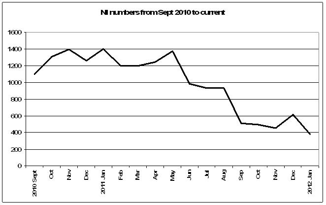
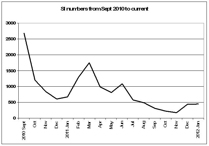
Surprising results
For the period 1 September 2010 to 21 January 2012
• The North Island has had more recorded earthquakes in total than the South Island
• The North Island has had a higher monthly average of numbers of earthquakes than the South island.
• The South Island has had only 6% more above-5mag events.
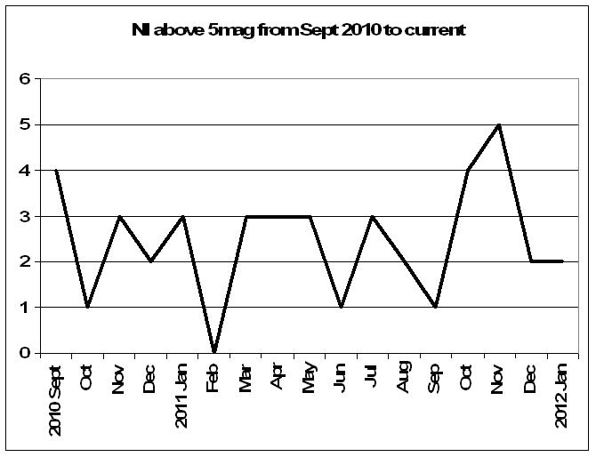
• The North Island has had at least one above 5-mag event/month for 16 months
• The South Island has had at least one above 5-mag event/month for 12 months
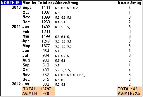
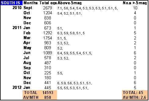
The figures above were obtained from http://magma.geonet.org.nz/resources/quakesearch/
The numbers also show a decreasing in number for both islands, and although the occasional resurgence happens, such as we have seen over December and the first half of January, it has not been enough to reverse the general trend.
This trend shows that
• drops in the NI of above 5s have occurred every 4 months
• rises in the SI of above 5s have occurred every 5 months
(indicating that May or June may see another rise in high magnitude events in the SI. My picks would be 6-8 May and/or 3-5 June)
After April 2011, numbers of earthquakes somewhat lessened in the South Island, giving the misleading impression that earthquake activity may have been migrating north. In fact there have been more earthquake events in the South Island (compared to the North Island) in only 4 months out of the last 17 months, namely Sept 2010, Feb, March and June 2011. In other words there have been more in the north all along, but our focus has been on the South Island, for obvious reasons, and we have not noticed the bigger picture.
This confirms what we suggested in February, that overall numbers would diminish after April but an odd big one would visit now and then. Christchurch may not be exclusively “in the gun”, geologically-speaking, as things would appear from the media. Of course no one is denying the tragic loss of life, and the anguish that has come from bereavements and loss of property, but since Sept 2010 it is the whole country that has been affected, i.e. both islands, not just the South Island. Nevertheless the collateral damage has been almost entirely in Christchurch and all funding and reconstructive energies must be focussed there, despite the correct geological perspective.
The reader may think there is little point in saying that, but I feel it is useful to give Christchurch people the larger perspective. There are traumatised residents who think it is their area of the country that is cursed, and that their only hope of sanity is to leave. I am saying that much of NZ is getting shaken around. If NZ was still uninhabited, and let us pretend that we are looking at perhaps 1000 yrs ago, and a traveller was noting the earthquake activity in the whole country as laid out here, and he was wondering where to live, then perhaps he would choose the South Island because of the lesser earthquakes in number and the fact that there were some months that have had no large earthquakes at all, in comparison to the North Island. It is also probable that the area of sea from East Cape to the Kermadecs has always been active and will continue to be so for some time to come.
The South Island is worth rescuing and the recent words of the head geologist, we can “expect large shakes there over the next 30yrs" also applies equally to the North island.
In the overall scheme of things the figures above are not too surprising. We are all in this together and we all should pull together. It is the whole so-called “alpine fault line” of mountains that have been affected by the current spate of earthquake activity that started in 2010. It was the whole of NZ targeted, from the Kermadecs to Macquarie Island, and this was because of the position of the moon and the direction of the solar winds produced by the ongoing solar flares, in turn a result of powerful planetary alignments. Lately some activity has popped up in Taupo, but it is all part of the same chain.
I believe there is every reason to believe that this will continue to be the case over the next 1-2 yrs as it is following the usual timeline for this type of series, and any hope that the earthquakes are going to end in Christchurch tomorrow or even that they are specifically targeting Christchurch in the upcoming year, should be dismissed. The last series in the Canterbury region saw 12000 earthquakes in the first year, 2000 in the next, 600 in the third and by then it was all over. The only difference was that the epicentres and nearly all the events were in the hills about 90kms from the CBD, where hardly anyone lives, where there are no cathedrals, where there was no loss of life, and consequently the media hardly reported anything, so no one except the locals remember the series to this day.
Geology is a wonderful science, especially in the hands of passionate teachers like Te Papa's Dr Hamish Campbell, but earthquakes have been suddenly thrust upon us without warning. Traditional geologists mainly study rock formations and their formative histories, and comment on suitability of ground for development. W
e are going through a wind-down after a series of jolts to the country. It will take 2 years to be noticeable. But the Alpine Fault is not getting ready to blow and split the South island into two halves, “chem-trails” are not causing earthquakes and are only harmless jet vapour trails, and there is no evil organisation called HAARP causing earthquakes. Christchurch is not getting ready to become volcanic, and a tsunami is not gearing up to sweep away the city – all these scenarios have come from over-active imaginations. Volcanoes are not like earthquakes. Volcanoes give plenty of warning. There is not only the smell, but rumblings and mini-eruptions in the neighborhood. You'll know all about it well before a volcano happens.
Which brings us to tsunamis.
___________________________________________________________
Tsunami risk? Don't think so.
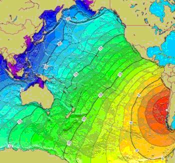
One thing I feel the reader might rule out with some confidence is the probability of a tsunami anytime soon. About a year ago it was uncertain where epicentres were drifting, and they appeared to be to the east, and steadily out to sea, but this has now ceased to be a regular pattern. It means tsunamic action is less likely. It doesn't mean it definitely won't happen; we are not gods so nothing is certain. We are talking only about likelihoods and what we can reasonably expect to happen, based on what already has. This is so we can get on with our lives, and where best to apply our anxieties. But any serious tsunami would still have to come from S America, probably Chile. There have been about 4 events in our history that might be called tsunamis. The first was in 1868 and came across from Chile. Another occurredin May 1960, also the afterwash from a massive Chilean earthquake, when waves 2m high entered Lyttelton Harbour damaging boats and a hotel. But we have never had a tsunami generated in local waters.
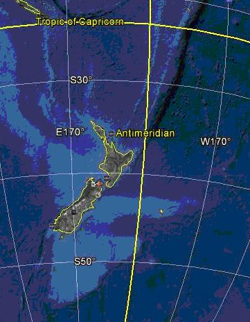
(acknowledgement Google Earth)
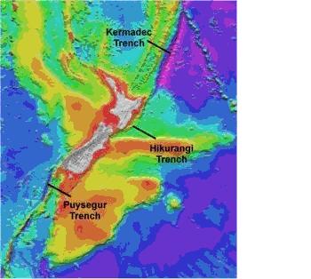
The land of which the South island is merely the above water top part, extends about 2000kms to the east, before it drops away. It can be seen here in Google Earth. The water is arguably too shallow to generate a large enough wave close enough to NZ shores to effect damage to the South Island coastline. Although the North Island is in more danger, even then there is a 200 mile plate extending to the east off the Wairarapa coast before you drop down to the Pacific Plate.
It is why tsunamis are so very rare here although it cannot be said that earthquakes are rare. Is it not somewhat a lesson to the tsunami alarmists that out of the 15,000 earthquakes that occur on average in NZ every year, and in the past year this has been closer to 30,000, not one has gone on to become a tsunami?
So can we put this one to bed? It appears not, because a modern tsunami warning system, costing thousands, paid for by hardworking NZers some of whom are still waiting for toilets to be restored, is right now being installed along the Kaikoura coastline. Meanwhile there is still no siren warning system being planned for Christchurch. There have been 30,000 earthquakes in the past 17 months and not one tsunami. Let us go further than that. At the rate of about 15,000 earthquakes on average per year in NZ, which from 1868 to present would be very roughly 144 years x 15000, or roughly 2 million events, divided by 4 for the tsunamis here that we know about, means a 1/500,000 chance, or 0.0002% risk of an earthquake event becoming tsunamic. That is terribly low. There is more chance of the Christchurch Council boss refusing his salary increase.
(acknowledgement NIWA)
http://ecan.govt.nz/advice/emergencies-and-hazard/tsunami/pages/tsunami-info-chch.aspx
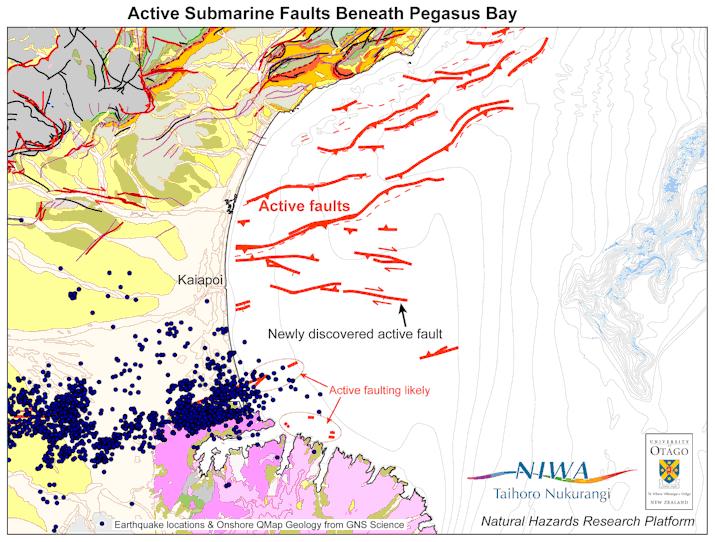
Scientists have discovered some earthquake faults on the sea floor in Pegasus Bay, but they appear to move very infrequently (once every few thousand or tens of thousands of years). They are not thought to be big enough, and would not produce enough vertical movement, to create a significant tsunami that would flood land, except perhaps very low lying areas and the heads of the bays of northern BanksPeninsula (PigeonBay and Port Levy)
(Ref: http://ecan.govt.nz/advice/emergencies-and-hazard/tsunami/pages/tsunami-info-chch.aspx )
Distant source tsunamis come from across the Pacific Ocean, most likely South America. This is our most likely tsunami threat. The four largest recorded tsunamis to hit Christchurch, Pegasus Bay and BanksPeninsula – 1868, 1877, 1960 and 2010 – were all distant source tsunamis from South America. Distant source tsunamis take 12-15 hours to reach New Zealand, so there is time to issue warnings and evacuate people if necessary, and read all of War and Peace. Tsunami sirens will be sounded for a distant source tsunami, once they are installed. Christchurch City Council has confirmed a budget for tsunami warning sirens and is currently working through the process of installing them. The sirens will not be used for a local tsunami because there will not be time to sound the sirens, so they say, but as there has never been a local tsunami it's all a bit of a playstation game. Sirens will only be used in the event of a distant source tsunami from across the Pacific Ocean, and "possibly for a regional source tsunami from the Hikurangi subduction zone". There will not be time to sound the warning sirens if there is a local source tsunami in Pegasus Bay – "earthquake shaking will be your only warning". You must run at that point. Presumably that also applies to elderly folk, the disabled and babies.
Will Civil Defence issue running shoes?
So..if they take 12 hours to reach NZ, of what use is a siren? Will it go for 12 hours? Is it not better to install sirens giving 30 seconds warning of a big earthquake occurring on OUR shores? 30 seconds is all it takes to get out of a building before it collapses. On 22 February a 30 second warning would have been better than nothing.
___________________________________________________________
Early earthquake series
Can we expect more earthquakes? The answer is sadly yes, we might as well be prepared for it. There is always a 2-yr timeline of wind-down after a big seismic event. Plus, in a volcanic region like the South Island, there will always be the risk of big ones on perigees, particularly when perigee is within a day or so like 4 Sept and 9 Oct 2010, 22 Feb, 13 June and on 23 December.
Have earthquakes ever stopped in Christchurch? No. Have there been as many and as big? Yes.
The first series was recorded in 1869-70. Thousands of earthquakes occurred over those two years but they are not in geological records. They started with the event on 5 June 1869.
http://www.lostchristchurch.co.nz/a-history-of-quakes-in-christchurch
http://www.naturalhazards.org.nz/NHRP/Hazard-themes/Geological-Hazards/February-22nd-aftershock/New-Zealand-s-deadliest-earthquakes-and-past-earthquakes-in-Christchurch
More past series have been described in our free newsletter. To join to receive them, click this link:
http://www.predictweather.com/Register.aspx
___________________________________________________________
How quickly stories change
(18 October) "the worst is over for a thousand years for Christchurch":
http://www.nzherald.co.nz/nz/news/article.cfm?c_id=1&objectid=10759977
http://www.nzweather.net/threads/aftershock-prediction-held-back-the-worst-quakes-are-over.14433/
(2 January), "more big shakes are in store"
http://www.3news.co.nz/Fears-another-big-quake-could-be-in-store/tabid/423/articleID/238109/Default.aspx
(3 January), "big earthquakes are going away":
http://nz.news.yahoo.com/a/-/mp/12482478/relief-for-chch-as-quakes-move-away/
Seismologists have confirmed earthquake aftershocks are slowly shifting away from Christchurch, easing the risk of any more sharp shakes across the city in coming days and weeks
(6 January) "the aftershocks in Christchurch are going to continue"
http://newsessentials.wordpress.com/2012/01/06/earthquake-experts-say-the-aftershocks-in-christchurch-are-going-to-continue/
http://www.stuff.co.nz/national/christchurch-earthquake/6222161/
“Councillor Helen Broughton asked the scientists if all 9600 shakes were "aftershocks" or if three or four could be classified as earthquakes. Bannister said the thousands of events could all be be described as "aftershocks" to the September 4 earthquake. Kelvin Berryman of GNS Science said "the sequence of quakes will decay over decades rather than years"
___________________________________________________________
What might Christchurch do?
Information is the key, as it always is. There are plenty of international scientists from different cultures who have different takes on earthquakes and their timelines. They should be brought here. There are cities in the world which have successfully evacuated before massive calamities. The designers of those warning systems need to be imported and/or interviewed. Would it work here? How many were evacuated? Who did the study, designed the program? What do we need to erect the systems?
All alternatives might be viewed with interest. The public do not want to see the same old faces saying the same old things, which is that “we know” and yet “we are surprised”. They are tired of, earthquakes cannot be predicted but we know when they won't occur, we expect a 6 or a 7 in the next 6 months but the big ones are all finished, Christchurch can rebuild with confidence but should wait, etc etc. The public want information, not posturing and they are paying to have it, through their taxes. The city should also look to how other cultures have managed their populations in previous crises. We are not the first city to suffer a damaging catastrophe. Others have moved on successfully, and have found ways to manage ongoing seismic activity in their regions.
From another city where I am, Christchurch looks to be a war zone with the fight on two fronts: coping with what nature is throwing, and fighting administrators for general assistance, basic compensation and insurance entitlements. A war-zone mentality entails closer unity, staying calm and managing casualties. It means protecting children, the elderly and the vulnerable, not only from external circumstance but also from anxiety and fear, because that will destroy from within. Fear is the enemy, not the earthquakes. My opinion is that families can eventually accommodate earthquakes, because it is a fact of life, it is also a learning curve and it can strengthen character if managed.
It is an opportunity most NZers do not get. Children from this location and this era may be the future leaders of NZ, because they may not experience again these scales of personal challenges. Just look at the behaviour of the youth of the Clean-up Brigade, who saw the need and acted. They did what the real service people could not either organise because of the number of chiefs and too few Indians, or because real immediate help is simply not the way things are now done. The group of students were unsung heroes. They deserved an award for initiative.
Where is that TV Mucking-in team when you need them? There's a whole city here that needs and is deserving of a makeover. Why is not every carpenter and tradesman in the country presently being shipped into Christchurch like an occupying army? So what if the quakes are ongoing - so is suffering and discomfort. Hospitals don't only open for business during epidemics. They run 24/7. So should the contractors.
___________________________________________________________
Whale strandings
Most earthquakes happen under the sea, because the crust of the land is thinner on the ocean floor, about 10kms thick compared to about 100kms thick on land. I believe whales and dolphins get affected because they swim in these trenches
(Ref: http://ecan.govt.nz/advice/emergencies-and-hazard/tsunami/pages/tsunami-info-chch.aspx )
chasing schools of fish, and the sloping sides of the trenches act like amplifiers. Matching swell patterns to sightings may in future reveal this real possible reason that whales are found mainly on certain beaches.
I believe it is not too farfetched to suppose that these poor creatures may get knocked out by the shock waves and float up. They then float in with the tide, too sick to move, some dying. Strandings were seen in many cultures in the past as signs of earthquakes, if not around at the same time, then soon due. Sometimes the strandings make the news and we can piece together the correlation for ourselves. But there is no international science hook-up of strandings and earthquake areas. There isn't one because modern science is out of touch with what they think is folklore and so it is not covered in their training, therefore it must be either unimportant (or they would have learned about it), incorrect or even in the evil/snakeoil/voodoo box. Yet folklore always came from repeated observations.
It is a reasonable reason for strandings, because there is usually the added correlation of seismic activity around the same time frame and geographical area. It is more likely the undersea shakes precede shakes observed on land, because a jolt undersea is probably a foreshock happening in a shallower land environment. Of course not all earthquakes will produce strandings because there may not have been whales in that area at the time. Also, some strandings could be possibly due to other causes, like illness. But the above is a possible reason. Nevertheless local scientists prefer to say it is all a mystery.
A look at the geography of the trenches gives a possible clue. Most strandings in and around NZ are near the known deep undersea trenches;
• around the lower SI and Stewart Island from the Puysegur Trench,
• at the east and top of the SI around Farewell Spit, and the Wellington area around to South Taranaki near the Hikurangi Trench,
• and in Coromandel and Bay of Plenty from the Kermadec Trench.
There are few strandings reported near Taranaki, Westport or Dargaville. I have Googled these and found that in the past 25 years, there has been just one recorded instance of a whale becoming stranded on the Taranaki coast, a rare baby pygmy right whale at East EndBeach in 2000.
We can take from reported whale strandings, confirmation of seismic activity at sea. As we are surrounded by both the sea and plate boundaries, we can also take strandings as a sign to be vigilant in case the earthquake cluster is still unfinished.
http://www.odt.co.nz/news/national/193593/whale-stranding-near-nelson
Pilot whale stranding at GoldenBay
7:58 AM Saturday Jan 7, 2012
About 20 pilot whales have spent the night stranded on Farewell Spit in Nelson's Golden Bay
.
http://www.stuff.co.nz/marlborough-express/news/kaikoura/6240402/Whales-closer-to-shore
Whales closer to shore Quakes may be the cause
JARED NICOLL
Last updated 11:48 11/01/2012
Reports of whales coming unusually close to the coast have been piling up since large aftershocks hit Christchurch on Christmas Eve.
http://www.scoop.co.nz/stories/AK1201/S00406/second-golden-bay-whale-stranding.htm
Second
Golden
Bay
Whale Stranding
Monday, 23 January 2012, 3:52 pm
Press Release: Project Jonah
___________________________________________________________
Banks Island
In the 22 December newsletter we mentioned how in Captain Cook’s time at least three maps were drawn up, by different cartographers, showing Banks Peninsular drawn and named as an island.
In those days you recorded solid lines where you had been and observed, and you left gaps or dotted lines where you couldn't see around corners or hadn't gone exploring into bays. Auckland was not explored and so the Hauraki Gulf coastline remains undrawn, same for Foveaux Strait. But the lines around Banks Island are solid. Cook made 3 trips to NZ and went up and down the east coast of the South Island 5 times. You would think he would have noticed a glaring error such as that on at least one occasion. Remember he was no klutz. Cook was selected to come here because of his cartographic skills. Plus, as it was such an obvious and basic source of potential error, map makers were always on the lookout for mis-drawing islands as peninsulars and vice versa. But Cook was not the only one who drew it as an island. So were all mariners on the same hallucogens? Isn't it more likely that Banks really was an island then? Probably very tidal, and probably avoided by Maori.
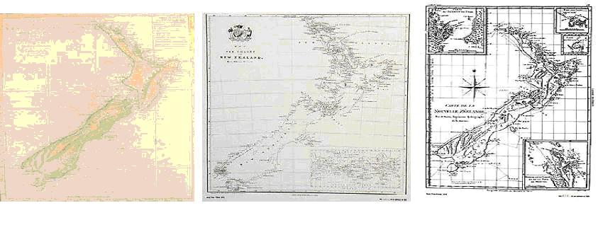
(Ref: http://www.prints.co.nz/page/fine-art/CTGY/New_Zealand_Map)
Therefore there appears to be scant record of Maori tribes occupying the current CBD area, giving even more weight to the theory that it may long have been covered over by sea. There was a known settlement about the area of the botanical gardens police station area. It has just been revealed that early settlers built over an urupa (burial site) on Gloucester Street. The settlement was occupied by Waitaha and Kati Mamoe but not Ngai Tahu. Ngai Tahu just used the area as a main food gathering area. Settlements were also situated around what is now the Peinisular, on what is Lyttelton and the Banks Peninsular side of Lake Elsemere facing the mainland, perhaps, if it faced sea, because it may have been easier to see approaching invaders, But without oral stories or other records we do not know how old the settlement on Gloucester St was. There is no hope of doing archaeology in quicksand..
“the Canterbury Earthquake Recovery Authority (Cera) revealed that some red zone areas had dropped below sea levels since September 4, 2010, which started the earthquake sequence
.”
http://www.odt.co.nz/news/national/193504/christchurch-rattled-50-quake
If the ‘floor’ of the land residents are walking around upon has dropped below sealevel it can only mean that the surface ground height in the east of the city has, some 300 years later, still not stabilised, and seismic activity is still causing land height to be fluctuating around sealevel. On the one hand the situation suggests that the above maps were made when the land had dipped below sealevel, and possibly the big earthquake events of 1843 and 1869 brought the ground level higher. Presumably by mid 1800s roads had begun concealing these rises and falls and it may have been only gardens and low swamps that experienced liquefaction rising through on kingtides.
If the above is correct it may also mean that these areas, if below sealevel right now, may be due to return to sea, unless either levees or pumps are installed. But there has been no announcement about this, nor which areas maybe now subject to the dangers of submergence. For the sake of those remaining even near the area, the true extent needs to be revealed, because when flooding re-occurs they may be more anxious than need be about danger to existing dwellings. It could be the reason the government is so adamant that some red zone people are to be relocated without explanation and without delay, whilst some other properties are not included in the same urgency. In the absence of information the imagination works overtime! Unexplained surveying discrepancies, why one house may be declared uninhabitable whilst a neighbour in the same street may be left alone, has been somewhat of a mystery at times to locals. It is conceivable that no announcements are made because they would invite clamouring for more information, and it seems that the public are being discouraged from asking for any at all.
___________________________________________________________
Planetary alignments
It appears that the planets play a seismic role on earth the closer they are to the Sun, not to Earth. Alignments with the sun can last up to 3 or even more days, due to the sun’s size and consequently a greater gravitational shadow.
The order of influence seems to be Sun, Moon and Mercury, Jupiter, Venus, Uranus, Saturn and Neptune. Mars and Pluto may play little or no role.
The 11 greatest (mag 8.6+) earthquakes recorded since 1902, and their matching alignments have been:
• Earth-sun-Merc, Earth-sun-Venus, 22 May 1960, Chile, 9.5mag
• Earth-Merc-Jup, Earth-sun-Merc, 28 March 1964, Full moon, Alaska, 9.2mag
• Earth-Merc-Venus, Sat-Earth-Sun, Full moon, 26 Dec 2004, Indonesia (Asian tsunami), 9.1mag
• Earth-Merc-Uranus, 11 March, Japan, 9.0mag
• Jup-Earth-Sun, Jup-Earth-Merc, 4 Nov 1952, Kamchatka, 9.0mag
• Earth-sun-Jup-Moon, 27 Feb 2010 Full moon, Chile, 8.8mag
• Earth-sun-Venus, Nep-Earth-Ur, 31 Jan, 1906, Ecuador, 8,8mag
• Jup-Earth-Sat, 4 Feb 1965, New moon (-3) Alaska, 8.7mag
• Earth-Merc-Sun, Earth-Sun-Ven, 28 March 2005, Indonesia 8.6mag
• Earth-Merc-Sat, Jup-Earth-Sun, 15 Aug 1050, New moon(-2), Assam, Tibet, 8.6mag
• Earth-Merc-Ven, Jup-Earth-Sun, 9 March 1057, Alaska, 8.6mag
Jup-Earth-Sun, 3 May 2006, Tonga earthquake, 8mag.
We can note that three out of the six world’s strongest earthquakes (above 9mag) have occurred during Full moon.
A phase of up to three days can occur in lunar forcing which results in deep earthquakes. This was evident for the Alaska, 1965 event and possibly for the Tibet 1950 event also. Mercury-Sun-Earth was a player in both large Christchurch earthquakes of 4 Sep and 22 Feb, and Joe (the Barcaroller) suggests that for some reason Mercury’s position celestially affects NZ. I would agree except that I think the moon is probably usually the main player for determining timing.
As an alignment nears, foreshocks normally occur in days or weeks prior to the main event, followed by aftershocks as the alignments fade out. But the smaller events are earthquakes in their own right, in the same way as smaller rain-dumps surround a cyclonic passage and bring their own destructive effects. No one says that rain on succeeding days are “afterstorms”. A new shower is of itself, it is not part of a previous shower. A new tide doesn’t contain left-over water from the previous day.
Absence of land mass attenuates activity, because land rises and falls to a daily tide, and this is greater the more land there is to move vertically. This is why the Southern Alps, which are higher elevations of land, have the greatest movement in the country and hence the greatest earthquake activity within their proximity. Anywhere close to the mountain chain will be subject to greater risk than locations more distant. This is why risk areas are the West Coast of the South Island, Canterbury to Marlborough where the mountains cross to the South island’s northeast, then Wellington to Central Plateau and up through Bay of Plenty/East Cape districts. It is why the least danger from earthquakes in NZ is in Whangarei in the North Island and in Oamaru and Dunedin in the South Island.
But it is also why the Pacific Ring of Fire is so active, being the largest discontinuity of land mass in direct juxtaposition to large land tracts. Locations sitting astride this differential are more seismically active because the Ring of Fire absorbs most of the earth’s magnified vibrations. By acting so, it makes other regions relatively calm, like both sides of the Atlantic and around the Mediterranean. These latter regions do get very destructive earthquakes from time to time which are dormant for long periods. Ancient history reveals accounts of these, which destroyed cities like Armageddon.
In forecasting earthquake possibilities there is an understandable public desire for exact magnitude, time and location. This is impractical and too rigid because all factors are not known. There is therefore a tendency to throw the whole baby out with the bathwater, and for scornful sceptics to try to denigrate the whole of longrange science, which is as flawed as other sciences but endeavours to provide something useful. A successful prediction is one that can predict a strong or next strongest earthquake in a series to within a few days interval and at a handful of named locations.
I do believe that approximate forecasting can be feasible to within a few days by monitoring earth’s response to an astronomical alignment as it occurs. Location-wise, this can be done by narrowing the location to geographical frontiers whose oscillations as measured by drums and sensors are expected to reach a collapse mode sooner than others, as gravitational shadows traverse the earth. Magnitudes can be roughly determined by the candidate planets comprising the alignments. One day geologists may have to work with astrologers or astronomers to fix focus areas. It can definitely be done and computer models made.
___________________________________________________________
The nonsense of plate tectonics
The mechanism of earthquakes will be discussed more fully in the next private newsletter
http://www.predictweather.com/Register.aspx
and then in an extract form in a following article here in the public domain. Basically, earthquakes come about due to the interplay of sun, moon and planets within the solar system, particularly the gas giants, and their varying positions and distances from earth. Full moon, new moon and perigee and combinations of these can be triggers that determine timing. Sequences of gravitational attractions build when planets line up, a virtual tug of war taking place, with earth in the middle. Stress on a planet’s electromagnetic field means something has to give. There is in nature always a rhythm and a cycle, nothing is random. It has nothing to do with fault lines, which are old scars, being footprints of earthquakes going and not coming. Neither has it anything to do with tectonic plates, which move at the same time as earthquakes simply because they are in the way of emerging releases of pressure. A car might crash through a barrier. A geologist who believed in plate tectonics would have to say the sudden rubbing together of parts of a buckling steel barrier can cause a car to come out of nowhere and go crashing through it. A beer billboard comes to mind.
Consider a bouncing ball. There is no bounce in it until it is put under stress from being thrown at the ground by a force outside of itself. A ball sitting on a floor doesn't suddenly get up and bounce because it develops some internal stress. There is cause and effect in nature, not mysterious inner forces. Plates rubbing together? What makes them do that? Plate tectonics says it is a slow rubbing that builds up over millions of years. But that can’t explain why on the day of the 6.3mag earthquake in Christchurch on 22 February 2011, a volcano blew its top in Shiveluch, Russia, sending rocks 6kms into the air.
(ash plumes rose to an altitude of 5.5 km (18,000 ft) a.s.l. during 22-23 February
. http://www.volcano.si.edu/reports/usgs/index.cfm?wvarweek=20110223 )
It is inconceivable that a plate boundary fault line extends from Christchurch to Russia and doesn’t affect other places along the way. Plate tectonics does not explain how the moon, which has no tectonic plates, gets severe moonquakes. Plate tectonics only describes the effect, not the cause, like saying a ball bounces because the bottom pushes out. Or a car moves because the wheels turn. The ball bounces because external forces are applied to a body previously in a state of rest. A car moves because an engine, powered by externally applied fuel, makes the wheels turn.
The ground shakes because an area of planet earth, otherwise at rest, receives stress to its part of the overall electromagnetic field, which creates an inner pressure inside the earth at that point, anxious to be relieved which moves the tectonic plates above as the pressure comes through, and if a city just happens to be sitting nearby it will get pushed aside to let the pressure through. The relation between earth, moon, sun and planets causes earthquakes. That is the stress-mechanism. We have to ask, what external forces act on the planet to bring that stress, when do they come to a focus and where will be the flashpoint. I believe these questions can be answered, as they were known about in ancient Asian cultures that evacuated whole cities before earthquakes struck, thousands of years before the sciences of geology and seismology.
___________________________________________________________
Coming dates
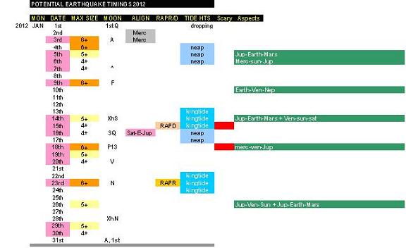
January
3rd : neap, apogee, (4-5 risk)
5th -6th : alignments Jup-Earth-Mars, Merc-Sun-Jup, building to northern dec, (4-5 risk)
9th : full moon, (4-5 risk)
14th -16th : Kingtide, moon crossing equator and alignments Jup-Earth-Mars + Ven-Sun-Sat, RAPD, (4-5 risk)
18th -20th : alignments Merc-Ven-Jup, neap, perigee and southern declination, (4-5 risk)
23rd : new moon, kingtide, RAPR, (4-5 risk date)
29th -30th : (4-6 risk)
---------------------------------------------------------------------------------
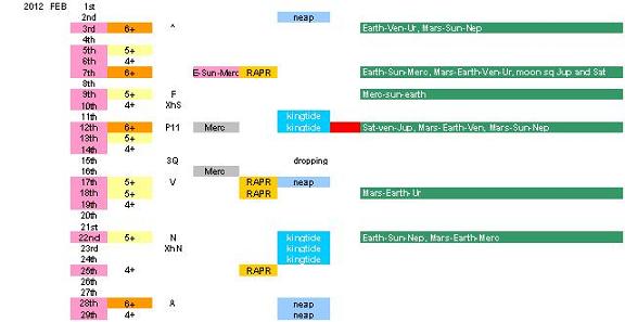
February
3rd: alignments Earth-Ven-Ur, Mars-Sun-Nep, N dec of moon, 5+ risk
5th : Midpoint apogee to perigee, (4-5 risk)
7th: Earth-Sun-Merc, Mars-Earth-Ven-Ur, moon sq Jup and Sat, RAPR (4-5 risk)
9th : full moon, alignment Merc-Sun-earth, (5+ risk)
12-13 Feb: perigee, air pressure swings in Christchurch, alignments Sat-Ven-Jup, Mars-Earth-Ven, Mars-Sun-Nep, (5-6 risk date)
17-19: midway perigee-apogee, neap, RAPR (4-5 risk date)
22 Feb: new moon, kingtide, alignments Earth-Sun-Nep, Mars-Earth-Merc, (4-5 risk)
26-28 Feb: apogee, neap, alignments Jup-Ven-Sun + Jup-Earth-Mars (5+ risk date)
___________________________________________________________
Further ahead
We have already mentioned May and June.
As for 3 June, that is a day prior to perigee and alignments on the 2nd are Earth-Venus-Sun, Saturn-Mars-Sun, Saturn-Venus-Uranus, Mars-Earth-Neptune, and Mercury-Sun-Pluto, which is quite a group. These all last in combo for about two+ days. So we have 2nd -5th as a potential risk time.
As for 2 July, the alignments are Sun-Earth-Pluto, Merc-Venus-Neptune, Sat-Venus-Uranus. The perigee is on the 2nd. So there may also be risk then.
There is also a risk date in August.
Much further ahead, Wellington may be subject to the potential for an above-7mag event in the next half-decade.
Reasons and more about this in our next private newsletter. To join click here. http://www.predictweather.com/Register.aspx.
___________________________________________________________
The table for the year
Many correspondents have requested this, the equivalent that was and still is on our website all through last year. Release of the whole table is not an easy issue. It has already been written and covers all biggest alignments, moon phases and risk dates until the beginning of 2014, but the difficulty is finding a way to get it into the public arena without incurring the wrath of politicians.
http://www.nbr.co.nz/article/nick-smith-ken-ring-offensive-should-be-held-account-ck-88242?page=2
This threat of legal accountability is something I take seriously. After all, the minister is the law
.
Here are my tables for January and February. Please note that the magnitudes are guesses of maximum potentials: they are not predictions. The whole table is of potentials only, based on the parameters listed along the top. Potential is often confused with certainty. But it is like crossing a busy road. There is potential for an accident each time. It doesn't mean you will have one each time you cross. It is risk only, provided all factors come together. I do not know of anything for certain. That would make one a god. But if there are factors that can be seen looming, then there is no harm done in pointing to them.
___________________________________________________________
Disclaimer and Conclusion
This work is not to scare anyone, just the very opposite. It is no different to Metservice or NIWA talking about the potential for cyclones, snow events or floods. They are opinions of people in the field, as are mine. Prior to 20 March I was interviewed by the media only twice: by Marcus Lush and John Campbell. The media came to me. What followed the John Campbell Show was the most Googled story in NZ and the biggest media beatup of one individual of 2011. It was an example of how people, in this case adult journalists, were fearful of what they did not understand, like children afraid of the dark. Some thought because I use orbits of moon and
planets ipso facto I must be an astrologer. There is nothing about moon, sun, planets, tides, cycles, patterns, and prediction based on observations that is not science. I have never done a horoscope for anyone in my life. But what if I have done? I do not have any need to hound the millions who find interest and comfort in astrology and other pursuits. Open-mindedness is science, exclusion of new ideas is bigotry. Easily upset people do not have to read what I write.
Many value information so that they can responsibly make choices and decisions, presumably including the 1500 Cantabrians who prior to 28 February 2011 contacted the TV station asking that I be brought onto their show. It couldn’t have been that after 6 months of the ground shaking to pieces under their feet the 1500 felt they needed more anxiety. Rather, the unavailability of information was adding to their fears, and I was asked to share what I knew.
It was a set-up and a stunt, which backfired badly on the station. Even the later "apology" was false. I am still committed to sharing information that may lessen anxieties. I feel there is still a long way to go for us all. Thank you.
___________________________________________________________
© Ken Ring 2012