El Nino update
FRIDAY MAY 15, 2015
The BOM (Bureau of Meteorology-Australia's weather service) is saying now that there is a 70% chance of El Nino developing in 2015, and that it could be full blown by mid May.
http://www.bom.gov.au/climate/enso/
As well, their eight international models are all calling for a new El Nino coming. The BoM was saying the same last year, namely that in 2014 there was a 70% chance of El Nino occurring that year, and yet it failed to eventuate. Again it was a case of a climate model failing to deliver accurate predictions.
http://www.reportingclimatescience.com/news-stories/article/doubts-surface-over-2014-el-nino-development-as-warming-stalls.html
Sooner or later, if some scientist keeps saying something year after year, it will occur and then their method will be hailed as a great breakthrough. (It's what seimologists do about an imminent monster earthquake in NZ, something they call the Alpine Fault Blowout). But we consider that we have not changed our story. All through 2014
we have been saying that the next El Nino would not arrive before the autumn of 2015, and it cannot be said we have vaccillated from this prediction.
https://nz.news.yahoo.com/opinion/a/21745961/el-nino-this-year-probably-not/
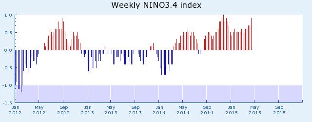
For those still confused, the El Nino condition is the name given to an above 0.4C sea surface temperature differentiation between Darwin and Tahiti, that has to last more than for 5 consecutive months. It signals a reversal in wind direction reaching Australian shores, and so a change in weather patterns. This can be seen in the BoM chart below to be finally getting underway, after a false start towards the end of last year. The red lines represent weeks.
Down the track there will be again a monsoon season in 2015-16 but one that will be starting to weaken, and that will be followed in 2017 by a dry year with a light monsoon. We are working our way towards the next Jupiter/Saturn opposition, which is typified by no monsoon season.
Past examples of this opposition and lack of monsoon have been 1930-32, 1951-55, 1987-89, 2004-6, and 2011-12. The difference is the averaged lunar and solar cycle of approximately 19-23 years, with a midway point around 2020 and a further quarter-way pulse this year. Usually there are two El Ninos per decade. The year 2020, +/- one, will herald both an El Nino year and a big drought that may be as devastating to some areas as was the 1901 Great federation Drought. It is a few years off but will seriously affect the east of the country.
This coming El Nino is likely to be a 12-month one, starting this July. Having said (all through last year) that a 12-month El Nino would not be due until this mid-year onwards, we have the news that Professor Roger Stone from the University of Southern QLD is saying that the drought over much of Queensland is set to continue into at least Autumn 2016.
https://www.google.co.nz/webhp?sourceid=chrome-instant&rlz=1C1GGGE_enNZ520NZ523&ion=1&espv=2&ie=UTF-8#q=roger%20stone%20el%20nino%202015
If Professor Stone and his colleagues can really see into the future now and are not just guessing, then this is wonderful news and a scientific first. It would be a departure from what the BoM and CSIRO have always claimed, which is that no one can predict ahead for longer than a week.
And yet, if they can indeed now look way ahead, then how did their computer models completely miss the NSW floods and loss of life of the past few days which took everyone by surprise? That does not make logical sense. Our almanac for NSW for 2015 has indeed mentioned the gales and thunderstorms for North Sydney, Hunter and Metropolitan areas, on p131 of this year's NSW almanac: The actual quote says:
April 18th:
Chance of thunderstorms in the Northwest Slopes and Plains, Southwest Slopes, Central Tablelands and Mid-North Coast. Strong winds and gales likely in the Upper and Lower Western, Central West Slopes, Southern Tablelands, Hunter, Metropolitan and South Coast districts.
April 19th
Strong winds for the Hunter, Metropolitan and South Coast regions.
(Also there is an entry for gales and thunderstorms on p134 in the severe events table). We were perhaps a couple of days early but that is within the 1-2 days leeway in all forecasting.
The lunar method is about timing of events, rather than rain amounts, which have more to do with the sun's evaporation rate prior to a particular date. The 11-12 year solar cycle is not as predictable as the 18-20 year lunar cycle, because the solar cycle varies between about 9-14 years, but it does enable us to predict dry and extremely dry years that repeat for specified regions, by combining the two cycles.
So, returning to El Ninos, we, that is Prof Stone and I, appear to be on the same page with one of us by having a workable system of solar/lunar cycles, and the other by some process that is difficult to tell, because there is no agreement about cycles in the corridors of climatology departments. Some say PDO, others say ENSO, AMO, SOI, IPO, NAO, or QBO. I make it simple and point to sun and moon, which all of the above are part of, if only weather scientists would look up at the moon. And given that ongoing funding comes from the global warming hoax, which embraces a view about climate and weather that is anomalous, one-off unusual and forever bizarre, which is anaethema to cycles, serious solar-lunar research is probably still some way off.
Leaving aside the politics, and given that an El Nino is finally agreed to be arriving soon, how might this affect Australia and NZ?
In NZ, classic El Nino winter patterns are more anticyclones for the Tasman Sea and ridges of high pressure over central New Zealand. These result in more frequent southerlies over the North Island, with westerlies and southwesterlies over the South Island which makes winter sunnier and more settled with less wind than usual over the country. It is bad news for the ski industry because of dry, mild, sunny weather and higher pressures.
For Australia, the 4-5 yearly El Nino, as typified by 1905, 1914, 1940, 1941, 1946, 1965, 1972, 1977, 1982, 1991, 1994 and 1997, brings dry conditions across much of eastern Australia, the northeastern half of Tasmania, almost all of Victoria, almost all of New South Wales (excluding coastal districts), eastern and coastal parts of South Australia, and much of Queensland. Small coastal areas in southern Western Australia are affected, as is the north of the Northern Territory..
ref: http://www.bom.gov.au/climate/enso/ninocomp.shtml
This year, for QLD in our 2015 almanac, we predicted tropical cyclones January to March, then that a dry winter will be followed by a wet spring. With the last of the cyclones dying away around the first week of April, we are happy to be on track. For NSW, the southern half of the State is facing a dry year, with the El Nino in autumn. For SA, not much rain should be expected between mid March and mid August. For central VIC, a very dry year looms. And for WA, rain almost completely stops between mid June and mid September. NT will have average rain figures or higher.
So far, meteorological scientists seem to have no clear idea about this El Nino, although that does not stop media announcements. Using their claimed look-ahead skills it would be useful to hear their opinion on what each State can now expect for the rest of the year. They have the computer climate models, the funding, the ear of the media and new enthusiasm for predicting months ahead.
For more information email ken@predictweather.com